ozoud
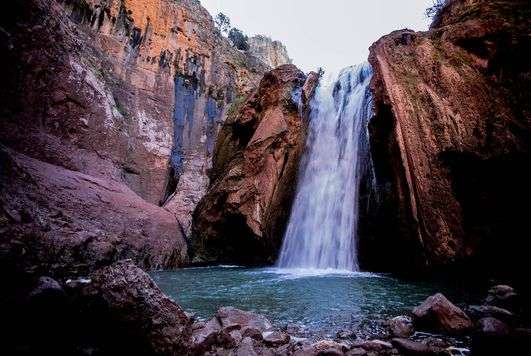
One of the most spectacular sights in Morocco, the Cascades d'Ouzoud attract large numbers of visitors. The waterfall is particularly impressive in spring, when the waters pour down from the top of reddish cliffs, crashing off a succession of rocky ledges to fall into the canyon of Wadi el-Abid 100 m (328 ft) below.
The road to the site leads to a spot above the waterfall , which can be reached along a footpath with steps cut into the earth. From platforms set at intervals on the path, visitors can marvel at the majestic succession of cascades and admire the permanent rainbow created by the mist thrown up by the water. Mills, whose only vestiges are small rectangular recesses, once worked a grindstone on which corn and barley were ground to make flour.


The fig trees and carobs that grow beside the path are often full of monkeys - the beige-coated macaques whose eyes are outlined in black, Bathing is permitted in the natural pools. Starting from the bottom of the waterfall, energetic visitors wearing strong walking boots can hike to the Wadi el-Abid gorge.
Environs Six kilometres (4 miles) southwest of Demnate, on road R304, is Imi-n-Ifri, a natural bridge that has been partly carved out by the wadi. A track leads down to the bottom of the chasm.
Exploring The Middle Atlas
A varied landscape characterizes the Middle Atlas. The eastern part receives scant rainfall and is thus only sparsely covered with vegetation, but above the deep valleys rise Jbel Bou Naceur and Jbel Bou Iblane: reaching a height of 3,340 m (10,962 ft) and 3,190 m (10,470 ft) respectively, these are the highest peaks of the Middle Atlas. In the thinly populated central high plateaux between Azrou and Timhadit, lakes (known as dayet or aguelmame) fill the craters of extinct volcanoes and are surrounded by forests.
The western part receives the highest rainfall and arable areas have attracted denser populations. Here, plateaux and valleys are covered in forests of cedar, cork oak and maritime pine. From December, peaks over 2,000 m (6,564 ft) are covered with snow. The Middle Atlas is the territory of the semi-nomadic Beni M'Gild and Zaïana peoples.
Oum Er-Rabii Sources
A winding road runs above the valley of the Oum er-Rbia, then leads down to the wadi. The river's sources - more than 40 springs - form cascades that crash down the limestone cliffs, joining to form the Oum er-Rbia, the longest river in Morocco. The springs can be explored via a footpath.
Khenifra
In the folds of the arid hills and on the banks of the Oum er-Rbia stand houses painted in the carmine red that is typical of Khenifra. Until the 17th century, the town was the rallying point of the Zaſane tribe, which resisted attempts by the French to pacify the region.

In the folds of the arid hills and on the banks of the Oum er-Rbia stand houses painted in the carmine red that is typical of Khenifra. Until the 17th century, the town was the rallying point of the Zaſane tribe, which resisted attempts by the French to pacify the region.
Beni Mellal
The modern town of Beni Mellal ers and Jews well before the arrival of Islam, the town was knownlies at the foot of the Middle Atlas, on the edge of the great Tadla plain, where cereals are extensively cultivated.
Although it is devoid of any obvious appeal, it is still a convenient stopping-place. Inhabited by Berb successively as Day, Kasba Belkouche and Beni Mellal. In the 13th century, it stood on the border between the kingdoms of Fès and Marrakech, which were the object of bitter dispute between the Merinid and Almohad dynasties.
In 1680 Moulay Ismail built a kasbah here, which was restored on several occasions. The town is surrounded by orange groves (oranges from Beni Mellal are renowned), and olive groves stretch to the horizon.
Beetroot and sugarcane have replaced bananas as cultivated crops. All are unusually well watered thanks to the Bin el Ouidane dam. South of the town, in the lower foothills of the Middle Atlas, a road marked "Circuit touristique leads to the Ain Asserdoun springs, which run between trees and small gardens.
It is worth making the short detour to Ras el-Ain, a little further up. This stone and pisé borj (tower) offers a picturesque view of Beni Mellal and its orchards.
Environs The area around Beni Mellal has many waterfalls, springs, caves and wooded gorges populated by monkeys. About 10 km (6 miles) east, a road leads to Foum el-Anser where a waterfall crashes into a gorge. The rockface here is marked by artificial caves, access to which is difficult.
South of Beni Mellal, a hillside track leads up to Jbel Tassemit (2,248 m/ 7,378 ft), which is the departure point for scenic mountain hikes. Hikers can also reach the Tarhzirte Gorge and the Wadi Derna valley, 20 km (12 miles) northeast of Beni Mellal.
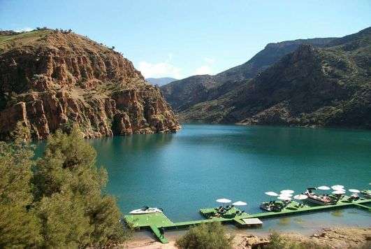
Bin el Ouidane
From Beni Mellal the road climbs through wooded hills to reach the grandiose site of an artificial lake, the Bin el Ouidane reservoir. The dam here is 285 m 1935 ft) long and 133 m (436 ft) high and the reservoir, with a surface area of 380,000 sqm (94 acres), is the largest lake in Morocco.
Fed by Wadi el-Abid and Wadi Ahansalt, it irrigates the intensively culvitated Tadla plain, while the hydroelectric generator provides a quarter of Morocco's electricity.
The turquoise waters of the lake, which are broken by spits of land and small islands, are surrounded by red hills, and the lakeshore is dotted with a few isolated houses.
Watersports and fishing are permitted on the lake and Wadi el-Abid is suitable for kayaking and rafting in spring, when the water level is sufficiently high. A track leading from the lake ends at a rock formation known as La Cathédrale.
This rock, with a covering of red soil and a setting among Aleppo pines, is well known to abseilers.