
IFRAN & midle atlas
The modern town of Ifrane was established by the French administration in 1928 during the protectorate era for their administration due to its Alpine climate. Ifrane was conceived as a “hill station” or colonial type of settlement.
It is a resort town set high up in the mountains so that Europeans can find relief from the summer heat of tropical colonies.
Ifrane is also a popular altitude training destination.
The first permanent settlement of the area dates to the 16th century, when the Sharif of Sîdî 'Abd al-Salâm established his community in the Tizguit Valley, seven km downstream from the present town.
Ifrane is a colonial “hill station”, and a “garden city”. It is also an a mountain resort, a provincial administrative center, and a college town.
Exploring The Middle Atlas
A varied landscape characterizes the Middle Atlas. The eastern part receives scant rainfall and is thus only sparsely covered with vegetation, but above the deep valleys rise Jbel Bou Naceur and Jbel Bou Iblane: reaching a height of 3,340 m (10,962 ft) and 3,190 m (10,470 ft) respectively, these are the highest peaks of the Middle Atlas. In the thinly populated central high plateaux between Azrou and Timhadit, lakes (known as dayet or aguelmame) fill the craters of extinct volcanoes and are surrounded by forests.
The western part receives the highest rainfall and arable areas have attracted denser populations. Here, plateaux and valleys are covered in forests of cedar, cork oak and maritime pine. From December, peaks over 2,000 m (6,564 ft) are covered with snow. The Middle Atlas is the territory of the semi-nomadic Beni M'Gild and Zaïana peoples.
Ifrane
63 km (39 miles) south of Fès Established in 1929 during the Protectorate, Ifrane is a small, noticeably clean town with a European rather than a Moroccan character.
Located at an altitude of 1,650 m (5,415 ft), it is cool in summer and may be snow-bound from December to March. On the descent into the valley, a green-roofed palace, the King's summer residence, comes into view.
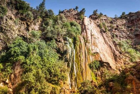
Al-Akhawaya University, inaugurated by Hassan II in 1995, has contributed considerably to the town's development. Ifrane serves as the departure point for many tours, including a trip to the waterfalls known as the Cascades des Vierges, 3 km (2 miles) west, and north to the zaouia 1 of Ifrane, which is surrounded by caves and koubbas.
Proximity
Out of Ifrane, going up to the Tizi-n-Tretten Pass, leads to the Forêt de Cèdres, After running along the Mischliffen and Jbel Hebri, it reaches a legendary 900-yearold cedar, the Cèdre Gouraud.

Mischliffen
A shallow bowl surrounded by cedar forests, the Mischliffen is the crater of an extinct volcano. The villages here are outnumbered by the tents of the shepherds who bring their flocks for summer grazing. A small winter sports resort (also called Mischliffen) has been set up, at an altitude of 2,000 m (6,564 ft), among the trees. The resort's facilites, which consist of just two ski-lifts, are, however, relatively basic.
Azrou
48 km (30 miles) south of Ifrane. A large outcrop of volcanic rock at the entrance to the town gave Azrou (meaning "rock" in Berber) its name. At an altitude of 1,250 m (4102 ft), it is located at the crossroads of routes linking Meknès and Erfoud, and Fès and Marrakech.

The town nestles in the centre of a geological basin, with Jbel Hebri to the southeast. It is circled by a dense belt of cedar and holm-oak, where the Beni M'Gild, the most prominent Berber tribe in the region, once came to spend their summers.
These nomadic pastoralists from the Sahara gradually adopted a sedentary lifestyle and founded the town. Azrou is still a regional market town, with a large weekly souk.
At the crafts centre (opposite the police station) items made of cedar, thuya, walnut and juniper are on sale, as are wrought-iron objects and the renowned carpets, with geometric motifs on a red background, made by the Bni M'Guid.
Imouzzer Kandar
Built by the French, the small hillside town of Imouzzer du Kandar overlooks the Saïss plain, which abuts the plateaux of the Middle Atlas. At an altitude of 1,345 m (4,414 ft), the town is pleasantly cool in summer, providing a welcome respite from the heat of Fès and Meknès.
Many Moroccans come here for the weekend. The dilapidated kasbah of the Aït Serchouchène, where the souk takes place, contains troglodytic dwellings, of which there are many in the region.
The caves were dug into the hillside and, in times gone by, protected Berbers from attacks by their enemies. Some are still inhabited. Steps or just a slope lead up to the entrance.
The openings - no more than a small door and a few ventilation holes - are small so as to keep out the cold, and the spartan interiors have neither water nor electricity.
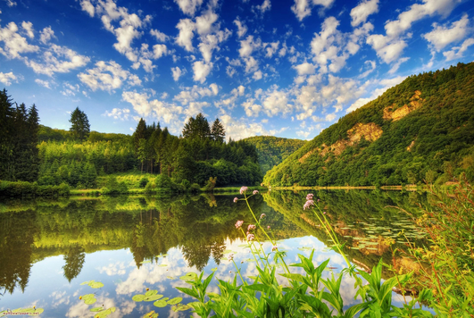
Lakes Tour
Three attractive lakes - Dayet Aoua, Dayet Ifrah and Dayet Hachlaf-lie 9 km (6.5 miles) south of Imouzzer du Kandar. A turning off to Dayet Aoua, which formed in a natural depression. The narrow road running along it leads to Dayet Ifrah, surrounded by a cirque of mountains, and on to Dayet Hachlaf.
Dayet Ifrah
This is one of the largest lakes in the area. Shepherds set up their tents on the lakeshore, and two hamlets face each other across the water, their white minarets rising up into the sky.
Bird sanctuary
When the lakes are full, the area becomes a nature reserve for many species of birds. It attracts waders - such as avocets, cattle egrets, grey herons and crested coots - Wildfowl, birds of prey - such as red kites and kestrels - and swallows
.
Vallée des Roches
Surrounded by a natural amphitheatre of hills, A track on the right, beyond the forestry hut, leads to these outcrops of limestone, strangely shaped by erosion, and to caves inhabited by bats.
Dayet Aoua
Its in a natural depression surrounded by hills. It sometimes remains dry for several years in a row and this is due to persistent drought and the fact that the water table has been tapped to irrigate orchards in the area.
Rock formations
Continuing along the direction of the Ifrane Mischliffen road, a rough track branching off to the right leads to this circle of rocks which, shaped by natural forces, have the appearance of ruins.
The Atlas lion
Before World War I, the roaring of lions in the Moroccan Atlas could be heard at dusk and during the night. The last Atlas lion was killed in 1922. During the Roman period, lions were plentiful in North Africa They flourished in Tunisia until the 17th century, although by 1891 not one remained. In Algeria, the last lion was killed in 1893, about 100 km (60 miles) south of Constantine.
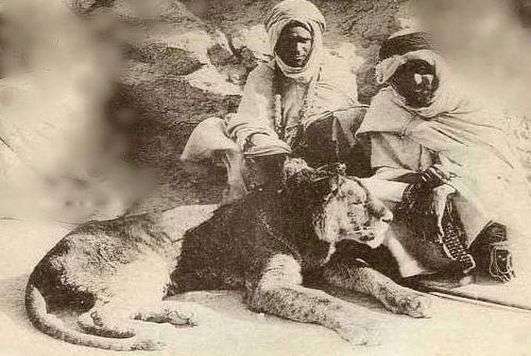
The lions of the Atlas were large, with a thick mane, which was very dark or almost black. Because the genetic make-up of the Atlas lion is known, it should be possible to bring this extinct sub-species back to life. With this end in view, a breeding programme under way, using lions bred in circuses and in zoos, most particularly the zoo in Rabat.