
CHEFCHAOUEN
Enjoy the day taking in the graceful, mysterious charm of Chaouen. With origins in Hispano-Moorish culture, its treasures remained hidden and cherished for hundreds of year.
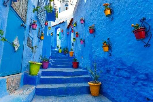
As night falls on its rose-pink tiles and white walls, the town’s history stirs, its winding street, sparkling fountains and gardens echo with unexpected and enchanting sounds. Chaouen is also known for its blue-tinted houses and buildings that come from the town’s former Jewish population.
The city was founded in 1471 as a small kasbah (fortress) by Moulay Ali ibn Rashid al-Alami, a descendant of Abd as-Salam al-Alami and Idris I, and through them, of the Islamic prophet Muhammad. Al-Alami founded the city to fight the Portuguese invasions of northern Morocco.
Along with the Ghomara tribes of the region, many Moriscos and Jews settled here after the Spanish Reconquista in medieval times. After eight years of the creation of the Spanish Protectorate in Morocco the Spanish Army could effectively take Chaouen, when General Dámaso Berenguer occupied the city on 14 October 1920.
Following the 1924 retreat of the Spanish army from the city, Chaouen was part of the Republic of the Rif (led by Abd el-Krim el-Khattabi) from 1924 to 1926.
In September 1925, in the middle of the Rif War, a rogue squadron of American volunteer pilots, including veterans of World War I, bombarded civilians in Chaouen. Colonel Charles Sweeney had proposed the idea to French Prime Minister Paul Painlevé, who "warmly welcomed the Colonel's request.
After al-Khattabi was defeated with the help of the French, he was deported to Réunion. The Spanish Army retook the city in 1926.
Exploring Chefchaouen
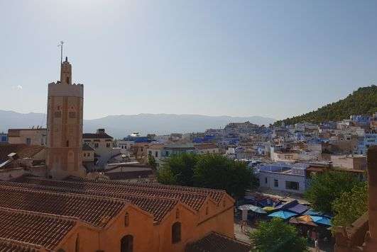
The white town of Chefchaouen nestles in the hollow of the two mountains - ech-Chaoua (The Horns) - from which it takes its name. Steep narrow streets with white and indigo limewashed buildings, small squares, ornate fountains and houses with elaborately decorated doorways and red tile roofs make this a delightful town. It was founded in 1471 by Idrissid shorfa, descendants of the Prophet Mohammed, as a stronghold in the fight against the Portuguese. Chefchaouen, esteemed as a holy town, has eight mosques and several zaouias and marabouts.
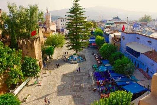
Uta el-Hammam Square
The square is the heart of the old town and the focal point on which all the streets of the medina converge. It is lined with trees, and paved with stones and pebbles, and in the centre stands a four-sided fountain decorated with arches and crowned by a pavilion of green tiles. With shops and cafés, this is an ideal place for a relaxed stroll.
Grand Mosque
Place Uta el-Hammam. Closed to non-Muslims. The Grand Mosque was founded probably in the 16th century and has been remodeled several time since. The later minaret, which dates from the 17th century, is distinctive in being octagonal. It is decorated with three tiers of plain and lobed arches on a painted ochre background. The uppermost tier is decorated with zellij tilework.
Fondouk
Corner of Place Uta el-Hammam and Rue Al-Andalus. The fondouk still serves the purpose for which it was originally built. About 50 rooms, arranged around the courtyard, still accommodate travellers and passing traders.

It is a building of strikingly simple design, with a gallery of semicircular arches lining the pebblepaved courtyard. The only contrast to this simplicity is provided by the main entrance; the doorway is surmounted by an awning and framed by a broken horseshoe arch surrounded by interlacing arches.
Kasbah & Museum
West corner of Place Uta el-Hammam. Open 9am-6pm Wed-Mon (till 1pm Fri). Closed Tue & Fri pm. The kasbah, with crenellated walls of red beaten earth and ten bastions, is the essential heart of the town.
The fortress was begun in the 15th century by Moulay Ali ben Rachid, and was completed by Moulay Ismail in the 17th century, as was the residence within. The kasbah's plan and architectural style show Andalusian influence.
A pleasant garden with fountains is laid out within, from where there is a good view of the walls and the rampart walk. The Musée Ethnographique (Ethnographic Musem) occupies the residence built in the garden. This is a traditional Moroccan house with a courtyard and gallery on the first floor.
The museum contains displays of pottery, armour, costume, instruments, palanquins and painted wooden chests.
Medina
A small street running between the kasbah and the Grand Mosque leads to the Souïka district. This is the oldest district of Chefchaouen, and the town's finest houses, with carved and decorated doors, are found here.
The name souika, meaning "little market", comes from the district's kissaria, where there are many small shops along its narrow streets. The medina contains more than 100 weavers' workshops Indeed.
Chefchaouen is famous for the woollen jellabas that are woven here, as well as for the red and white striped fabrics worn by the women of the Jebala, a tribe of the mountainous western Rif.
One such weaver's workshop is located in Rue Ben Dibane, identifiable by an exterior stairway. One of the most distinctive fountains in Chefchaouen is Aïn Souika, set in a recess in the district's main street. Covered by a porch, it has a semicircular basin and interlaced lobed arches.
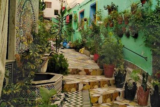
Al-Andalus Quarter
This district is reached from the northwestern corner of Place Uta el-Hammam, leaving the fondouk on the left. The Quartier Al-Andalus received the second wave of immigrants - Muslims and Jews expelled from Spain - who arrived in 1492, after the fall of Granada.

Here, the houses, painted white, green or blue, have decorated doors and wroughtiron railings at some of their windows. They follow the steep gradient of the terrain, which makes for many exterior stairways and entrances at various levels.
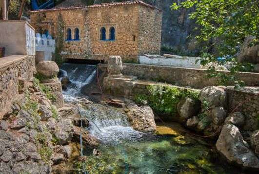
Ras El-Ma & The Mills
The steep streets of Al-Andalus leading up towards the mountain pass through Bab Onsar, the town's northeast gateway, which has been restored and renovated Beyond is the spring of Ras el-Ma, which is now enclosed by a building.
The presence of this underground spring was the reason why the town was established here.
It accounts for the town's lush gardens, and the water also powers the mills. Steps leading towards the metalled road run alongside the wash-houses, then the mills, whose origins go back to the arrival of the Andalusian refugees.
The route then leads to the bridge across Wadi Laou, which is built in the form of a semicircular arch with bevelled buttresses. With its cascades, wash-houses and cafés, this is one of the most pleasant quarters of Chefchaouen.
Exploring The RIF
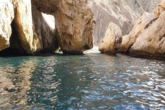
The great mountainous crescent of the Rif forms a natural barrier across northern Morocco. Its proud Berber-speaking inhabitants haughtily guard their traditions and independence, and historically the Rif has always resisted conquest. The Rif, today, is friendly and welcoming, with sandy Mediterranean coves and beaches, many of them with a backdrop of majestic cliffs.
Inaccessible and intricately partitioned, the Rif reaches a height of 2,452 m (8,047 ft) at Jbel Tidirhin, in the central part of the mountain range, then tails away eastwards towards the Moulouya estuary and the Algerian border. The northwestern Rif is a region of low mountains and hills dotted with villages, while the central part consists of lofty summits and enclosed valleys. To the east, what is regarded as the real Rif gently slopes away. All Riffians fiercely defend their cultural identity.
The Spanish, to whom the region fell when Morocco was divided under the French Protectorate, came face to face with this intransigence during the uprisings of 1921-6 and were soundly defeated at Anoual in 1921. The history of the Rif and its coastline is closely linked to that of Spain. For Morocco, the Mediterranean became a bridgehead for the conquest of Spain.
From the 15th century, the Portuguese occupation, followed by that of the Spanish, cut Morocco off from the Mediterranean and accelerated its decline. Spain still maintains a foothold in Ceuta and Melilla, and on a few rocky islets. Morocco has worked for closer cooperation with Spain and Europe to tackle problems of illegal trafficking and emigration here. The increase of tourism in Tangier and Ceuta has resulted in dramatic changes to the area, including a modern port and airport.
The RIF
The Rif This region is well known for its atmospheric and beautiful medinas but, covering an area of some 30,000 sq km (11,580 sq miles), it offers much else besides. Among its natural wonders are high mountains, capes, gorges and rock formations. The country souks held weekly in Riffian towns and villages provide the opportunity to come into contact with local people as they go about their daily business.
In July, the moussem of Jbel Alam, one of Morocco's best-known pilgrimages, takes place: the object is the tomb of Moulay Abdesselam ben Mchich, a highly venerated Sufi mystic who died in 1228. In the environs of Chefchaouen, ramblers and those with four-wheel-drive vehicles can visit one of the rare collective granaries of the western Rif at Akrar d'El-Kelaa, and the nature reserve at Talassemtane, where the fir forests are protected.
The Jebala District
In a landscape of hills and middlealtitude mountains, the villages of the Jebala tribe have taken root where springs cascade from the hillside, surrounded by olive groves and smaller cereal plantations.
Riffian Coastline
East of the small village of Torres de Alcalá there are some attractive and unspoilt coves and bays, including Kalah Iris, a haven of calm and solitude.

Mountain Crests Road
This road commands breathtaking views of the mountains villages and isolated houses of the Rif, as well as of the cultivated terraces, olive groves and forests of holm-oak that typify the region.
Al-Hoceima
The coastal town of Al-Hoceima, which nestles around the bay, is a modest resort that is quiet outside the tourist season. The busy harbour has many restaurants.
Gorge of Wadi Laou
Running between sheer high cliffs and below precariously perched villages, the gorge offers stunningly beautiful sights.
Ouazzane
(37 miles) south of Chefchaouen. 70,000. Thu A large market town, Ouezzane spreads out over the slopes of Jbel Bou Hillal, in a landscape of extensive olive groves and plantations of fig trees fed by abundant springs.
It is important for its textiles (jellabas and carpets) and olive oil. In the 15th century, the town, which was populated by Andalusians, also counted many Jews among its inhabitants.
It began to prosper in the 18th and 19th centuries under the influence of the Idrissid shorfa. In 1727, a descendant of Idriss || established the religious brotherhood of the Taibia, whose influence spread throughout Morocco, Algeria and Tunisia.
In the 19th century, the shorfa played a prominent religious and political role in Morocco. The sherif of Ouezzane's policy of openness also assisted trade relations with France.
The Zaouia (or Green Mosque) and, with its zellijcovered minaret, the Mosque of Moulay Abdallah Cherif, founder of the Taïbia brotherhood, attract many pilgrims. Jews also come to Asjen, 8 km (5 miles) west of the town, to venerate the tomb of Rabbi Abraham ben Diouanne, who died in about 1780.
The pilgrimage that takes place 33 days after Easter is an occasion when Morocco's Jewish community acknowledges its allegiance to the king.
Torres De Alcala
(89 miles) from Chefchaouen and 72 km (45 miles) from Ketama. Located on the estuary of Wadi Bou Frah, the fishing village of Torres de Alcalá lies at the foot of a peak crowned by the ruins of a Spanish fortress. About 5 km (3 miles) further east is Peñon de Velez de la Gomera, a tiny island attached to the mainland by a narrow spit of sand.

Held by the Spanish from 1508 to 1522, it later became a hideout for pirates and privateers. A convict station under the Protectorate, it is still under Spanish sovereignty. Some 4 km (2.5 miles) west of Velez is Kalah Iris, a cove that is an oasis of calm outside the summer season.
El Jebha
The small fishing town of El-Jebha nestles at the end of Fishermen's Point. Its onestorey, cube-like houses, covered in white roughcast, give it a typically Mediterranean air. On the right of the harbour, where lamparo boats are moored, is Crayfish Cove, which is ideal for underwater fishing. On the left, a soft sandy beach stretches away towards the west.
El Houceïma
The coastal town of Al-Hoceima, which nestles around the bay, is a modest resort that is quiet outside the tourist season. The busy harbour has many restaurants. This ancient fishing and trading port, seat of the emirate of Nokour during the Middle Ages, was long the object of dispute between European traders.
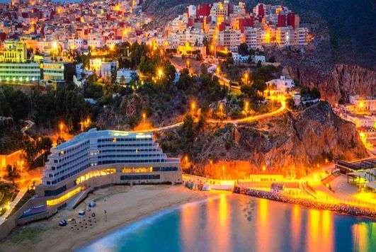
The modern town was founded by General Sanjurjo in 1926, at the place where the Spanish garrison landed, and was known initially as Villa Sanjurjo. The town's location is one of the most beautiful along Morocco's Mediterranean coast.
Whitewashed houses line the bay - an almost perfect semicircle between two hilly promontories. The coastline to the east, opposite the Penon de Alhucemas, a small island held by Spain, commands the most impressive view of the bay. A few dozen trawlers are usually moored in the harbou in the evenings their lamparo are lit up ready for a night's fishin Plage Quemado stretches out in front of the town.
This beach is better than others near Al Hoceima, such as tha at Asfiha, in the direction of Ajdir, opposite the small islar known locally as Nokour's RC The souk at Im Zouren, 17 km (10 miles) east on the road to Nador, is unusual: for the first few hours in the day, only women may go there.
Both Im Zouren and Beni Bou Ayach, large market towns on the road out of Al-Hoceima, have a slightly unreal appearance, created by largely empty residential blocks painted in ochres, blues, greens and pinks. The towns come to life for only a few weeks of the year, when emigrant workers based in Germany and Holland return.