AGADIR
Agadir, the regional capital of the South beyond the Atlas, draws thousands of visitors a year.
Its gentle climatetemperatures range from 7 °C to 20 °C (45 °F to 68 °F) in January, the coolest month – together with its sheltered beach and hotels make it Morocco’s second tourist city after Marrakech. Having been completely rebuilt in the 1960s after the terrible earthquake that destroyed the city,
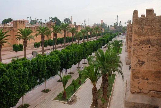
Agadir has none of the charm of traditional Moroccan towns, although its wide-open spaces and its modernity appeal to many holiday-makers. The industrial quarter consists of oil storage tanks and cement works, as well as factories where fish is canned (Agadir is Morocco’s foremost fishing port) and where fruit from the fertile Souss plain is processed.
Exploring Agadir & Moroccan Sahara
All roads heading into the deep South begin at Agadir, Morocco’s foremost coastal resort. To the east lies the great Souss plain, which stretches north as far as the High Atlas and south as far as the Anti-Atlas. This mountain chain of rocky peaks and stony plateaux culminates on its eastern side in Jbel Siroua, a remarkable volcanic massif that reaches a height of 3,304 m (10,844 ft), and whose western side, pitted with isolated valleys, slopes down towards the Atlantic. The resort of Agadir is linked to Tafraoute to the southeast, and to the numerous oases on the Saharan slopes of the Anti- Atlas. The road south links Agadir with the Saharan provinces, which start at the coastal town of Tarfaya. The focal points of human life in the Sahara are a few large towns surrounded by banks of dunes seemingly stretching to infinity.
Agadir’s History
The origins of Agadir are not fully known. In 1505, a Portuguese merchant built a fortress north of the present city. This was acquired by King Manuell of Portugal and converted into a garrison.
By then, Agadir had become a port of call on the sea routes to the Sudan and Guinea. A century of prosperity began in 1541, when the Portuguese were expelled by the Saadians. The Souss fell under the control of a Berber kingdom in the 17th century, but Moulay Ismaïl later reconquered the region.
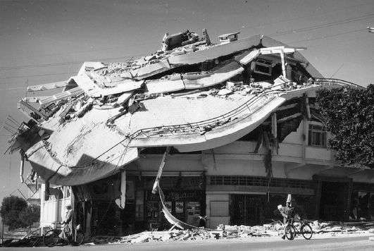
In 1760, Sidi Mohammed ben Abdallah sealed the city’s fate when he closed its harbour and opened one in Essaouira. In 1911 Agadir was the object of a dispute between the French and the Germans relating to its strategic location. On 29 February 1960 an earthquake destroyed the city.
Municipal Museum of Amazigh Heritage
Avenue Hassan II, passage Ait Souss. Open 9:30am5:30pm Mon-Sat. This museum was opened on 29 February 2000, on the day of the commemoration of the reconstruction of Agadir, forty years after the violent earthquake that destroyed the city.

The museum exhibits everyday objects derived from the peoples of the Souss plains and the pre-Saharan regions. Among the exhibits is a rich collection of magnificent Berber jewellery, superbly displayed alongside information on how the jewellery was made.
The Birds Valley
Avenue Hassan II. Open 9am-noon & 3-6pm Tue, pm-Sun. This open space in the heart of the city, laid out on a narrow strip of greenery, contains aviaries with a multitude of exotic birds. A small zoo features mouflons (wild mountain sheep) and macaques. There is also a play area for children.

Polizzi Medina
Ben-Sergaou. 10 km (6 miles) south of Agadir , towards Inezgane. Open 9am-6pm daily. Closed Tue This medina was created by Coco Polizzi, an Italian architect, who used traditional Moroccan building methods. Houses, restaurants and craft workshops have been built in the medina.

Beach
South of the city, the sheltered beach, in a bay with 9 km (6 miles) of fine sand, is Agadir’s main attraction, offering some of the safest swimming off Morocco’s Atlantic coast. However, although the city enjoys 300 day of sunshine a year, it is often shrouded in mist in the morning.

Sailboards, jet-skis and water scooters can be hired on the beach, and rides, on horses or camels, are also on offer. Many cafés, hotels and restaurants line the beach.
Old Kasbah
At an altitude of 236 m (775 ft), the hilltop ruins of the kasbah, within restored ramparts, offer a stunning view of Agadir and the bay. The kasbah was built in 1540 by Mohammed ech-Cheikh, to keep the Portuguese fortress under surveillance.
It was restored in 1752 by Moulay Abdallah and accommodated a of renegade Christians and Turkish mercenaries.
Port
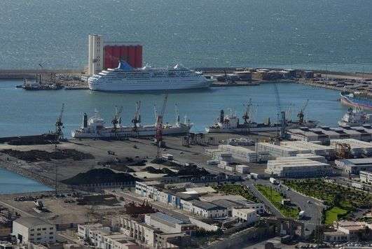
Located on the edge of the city, the port consists of a large complex with about 20 canning and freezing factories where the produce of the sea is processed. An auction takes place in the fish market here every afternoon. Agadir also exports citrus fruit, fresh vegetables, canned food and ore.
Taroudannt
Enclosed within red-ochre ramparts and encircled by orchards, orange groves and olive trees, Taroudannt has all the appeal of an old Moroccan fortified town. It was occupied by the Almoravids in 1056 and in the 16th century became the capital of the Saadians, who used it as a base from which to attack the Portuguese in Agadir.
Although the Saadians eventually chose Marrakech as their capital, they made Taroudannt wealthy through the riches of the Souss plain, which included sugarcane, cotton, rice and indigo. Under the Alaouites, the town resisted royal control, forming an alliance with Ahmed Ibn Mahrez, the dissident nephew of Moulay Ismail.
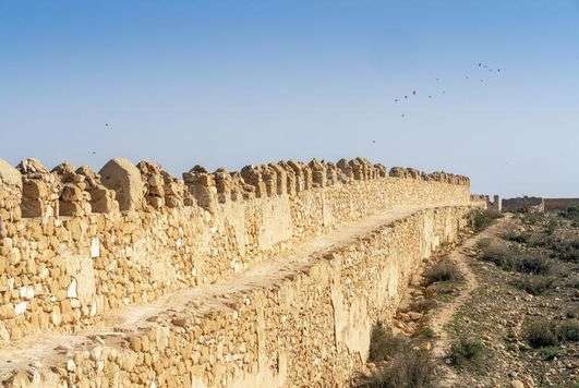
The latter regained control of the region by massacring the inhabitants. Taroudannt is a generally peaceful town, except during the annual olive harvest when it is enlivened by itinerant pickers. On its two main squares, Place Assarag and Place Talmoklate, horse-drawn carriages can be hired for a tour of the ramparts, which are 7 km (4 miles) long.
Set with bastions and pierced by five gates, they are in a remarkably good state of preservation, a part of them dating from the 18th century. The souks, between the two squares, are the town’s main attraction. The daily Berber market sells spices, vegetables, clothing, household goods, pottery and other items.
In the Arab souk the emphasis is on handicrafts: terracotta, wrought iron, brass and copper, pottery, leather goods, carpets and Berber jewellery of a type once made by Jews can be seen. Carvings in chalky white stone are a speciality of Taroudannt. Outside the ramparts is a small tannery, which is open to visitors. Its shop sells goatskin and camel-hide sandals, lambskin rugs, soft leather bags, belts and slippers.
Environs
The peaks of the western High Atlas – particularly Jbel Aoulime, at a height of 3,555 m – can be reached via road 7020, north of the town. About 37 km (23 miles) southeast of Taroudannt, the imposing Tioute Kasbah dominates the palm grove. This was the location for the film Ali Baba and the Forty Thieves, made by Jacques Becker in 1954.
A restaurant adjacent to the kasbah rather spoils the site. On the banks of Wadi Souss, which attracts migratory birds, stands the older Freija kasbah, now uninhabited. Between Taroudannt and Ouarzazate, the road (N10) passes through a landscape of wild beauty. Plains covered with argan trees give way to the volcanic massif of Jbel Siroua, which bristles with peaks and where soft geological folds alternate with rocky plateaux.
Taliouine, a town between two mountain chains at an altitude of 1,180 m (3,873 ft), has a stately kasbah once owned by the Glaoui (see p61). Though dilapidated, it is still inhabited. The town is the centre of the world’s biggest saffron-growing area. In Tazenakht, 85 km (53 miles) east of Taliouine, beneath Jbel Siroua, carpets with an orange weft are woven by the Ouaouzguite tribe.
Saffron From Taliouine
Saffron (Crocus sativus) is a bulbed herbaceous plant that belongs to the iris family. It grows at altitudes of 1,200 to 2,000 m (4,000 to 6,600 ft), in slightly chalky soil. Almost 6 sq km (2.3 sq miles) of saffron fields around Taliouine are cultivated by families, each of which tends its own plot of land.
The bulbs are planted in September at a density of 7,500 per 1,000 sq m (10,760 sq ft), and the mauve flowers appear at the end of October. Harvesting takes place before sunrise and goes on for 15 to 20 days.
It is a delicate process, involving the separation of the red stigmas that contain the colorant from the plant. After drying, 100,000 flowers produce 1 kg (2.2 lb) of saffron, and just gram (a tiny pinch) is enough to colour 7 litres (12 pints) of liquid.
The precious powder is then poured into airtight boxes and stored away from daylight to preserve its flavour. Good-quality saffron is sold in the form of whole filaments.
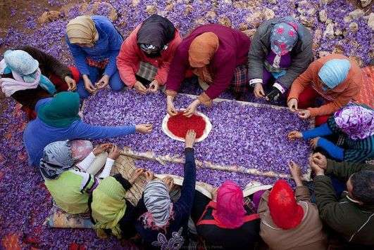
Saffron is used in food, as a dye for carpets and pottery, and for dyeing the hair and hands of brides. It is also a medicinal plant that is thought to aid digestion 1 and calm toothache.
Souss Massa National Park
Created in 1991, the Souss Massa National Park extends along the banks of Wadi Massa, which, en route to the Atlantic, irrigates a large palm grove. This nature reserve, where river and sea water meet, where tides ebb and flow, and where winter temperatures are mild, attracts hundreds of migratory birds.
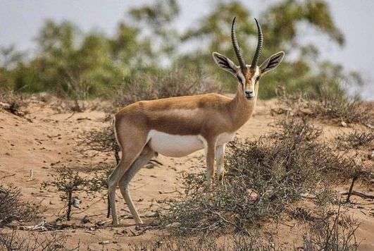
The reed beds on the banks of the wadi are inhabited by greater flamingoes from the Camargue, in southern France, and from Spain, as well as godwit , turnstone, snipe, dunlin, coots, grey heron and many other species.
The primary purpose of creating the park was to preserve the bald ibis, a species threatened with extinction. Morocco is home to half the world’s population of this curious bird, which has a pink featherless head Only certain areas of the park are open to the public.
. Visitors should approach the wadi from Sidi Rbat. The best time to see the birds is early in the morning, from March to April and October to November.
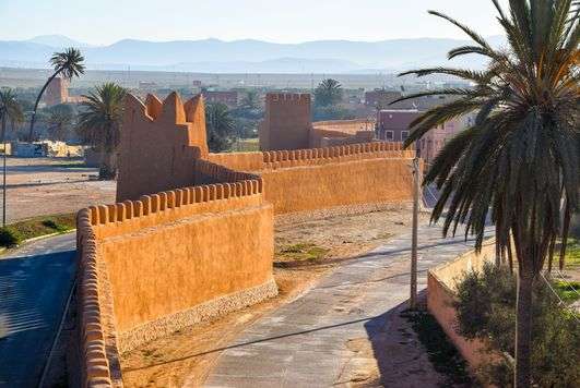
Tiznit
Located slightly inland from the coast, Tiznit is a small town where the proximity of both the Atlantic and the desert can be felt. In 1881, Sultan Moulay Hassan settled here in order to exert greater control over the dissident Berber tribes of the Souss.
The town came to fame in 1912, when El-Hiba, a populist rebel leader, was proclaimed sultan of Tiznit in the mosque. Opposed to the establishment of the French Protectorate in Morocco, El-Hiba conquered the Souss by rallying the tribes of the Anti-Atlas and the Tuareg to his cause.
He launched an attack on Marrakech, where he was repulsed by French troops. It is possible to walk round the 5-km (3-mile) pink pisé ramparts that encircle the town.
The méchouar, a rectangular parade ground that functioned as the pasha’s reception courtyard, is lined with arcades beneath which are cafés and shops. The renowned craftsmen of Tiznit still work with silver here, as the Jews once did, producing chunky Berber jewellery, daggers and sabres with inlaid handles.
The vertical poles on the clay walls of the minaret of the Grand Mosque are put there to help the souls of the departed enter paradise. Environs Sidi Moussa Aglou, 15 km (9 miles) northwest of Tiznit, is a fine beach used by surfers. Caves in the cliffs are used by local fishermen.
Sidi Ifni
From Tiznit, a scenic minor road leads to the coast, which it follows until Sidi Ifni. Formerly a Spanish coastal enclave, the town, on the crest of a rocky plateau overlooking the ocean, is buffeted by wind and is often shrouded in sea mist.

The colonial style of some of the buildings – such as the former Spanish Consulate and the Hispano-Berber Art Deco church that is now the law courts – gives the town an unusual aspect.
Tafraoute
At an altitude of 1,200 m (3,938 ft), Tafraoute stands in the heart of a stunning valley of the Anti-Atlas. It is surrounded by a cirque of granite whose colours at the end of the day change from ochre to pink.
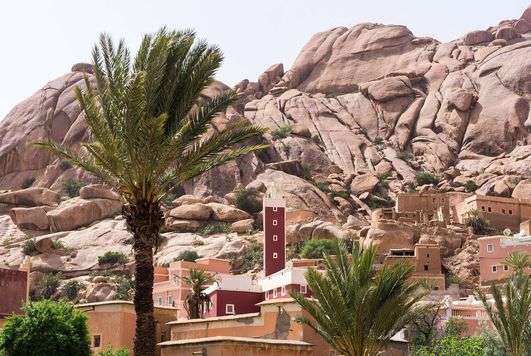
The palm groves here are lush and, for the brief period of their flowering – two weeks in February – the almond trees are covered with clouds of pink and white blossom The square dry-stone houses consist of a central courtyard and a tower.
They are rendered with pastel pink plaster and their windows are outlined with white limewash, Tafraoute is the territory of the Ameln, the best known of the six tribes of the Anti-Atlas.
They are renowned for their acumen as traders. As spice merchants, they have spread throughout Morocco and also abroad. Limited local resources have forced them to leave their homeland, so that their villages are today inhabited only by children, elderly people and women shrouded in black.
However, as soon as they can, the émigrés return to build comfortable houses. Tafraoute is also a centre for the manufacture of round-toed slippers, in natural, red, yellow or embroidered leather.
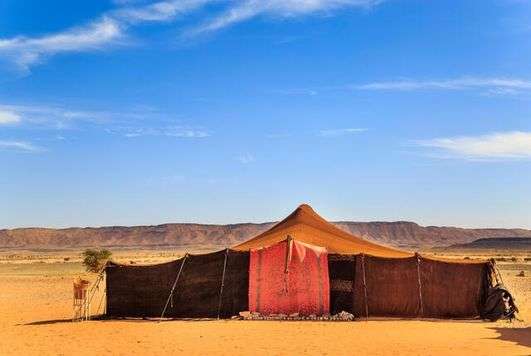
The Nomad’s Tent
The khaima, or nomad’s tent, seen on the desert plateaux of the High Atlas, outside the towns of Zagora and Guelmim, is the moveable home of shepherds who travel to provide protection against the heat. The brown fabric is woven from goat or camel hair. It consists of flijs, strips 40 to 60 cm (16 to 24 in) wide, sewn together edge to edge. It rests on a ridgepole supported on two vertical wooden poles. The interior of the tent is divided into two. One side, with basic cooking equipment and a loom, is for the women. The other side, separated by a screen, is reserved for the men and for visitors.
Nomads
are rarely seen because they mostly frequent mountain or desert environments that are remote from civilization. However, for a few weeks of the year, some of them settle in an oasis. Their tents are very simply furnished, with little more than thick, heavy carpets and wooden chests where the women keep their most prized possessions. The hospitality of the nomads is legendary
The nomad’s tent
is set up on level ground. In summer, the covering is laid over the poles in such a way as to allow air to circulate freely. In winter, the sides are drawn together and are insulated with long woollen blankets and carpets.
Nomadic Berber
women card wool before spinning it into yarn. Using a loom unchanged since ancient times, they weave blankets and lengths of cloth.
These nomads
Portrayed in a century-old photograph, lived in a way that hasn’t changed much to this day. Nomads still travel from one source of water to another.
Driving animals
to seasonal pastures occurs in Morocco’s more arid regions. In summer, the nomads take their herds and flocks up to the high pastures of the Atlas, returning to the south in winter.
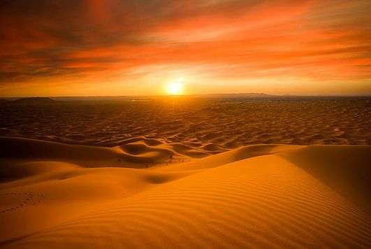
The MORROCAN SAHARA
The vast southwestern region of Morocco embraces a variety of spectacular landscapes. The fertile Souss plain, an area dotted with oases and extensive stony deserts, is bordered by the rugged mountains of the Anti-Atlas.
On the southern Atlantic coast, sheer cliffs give way to large areas of dunes linking Morocco to the Sahara and the republic of Mauritania Six thousand years ago, hunters forced northwards by the desertification of the Sahara moved into southwestern Morocco, as shown by the thousands of rock engravings that have been discovered in the Anti-Atlas.
The Arab conquest in the 7th century inaugurated the age of the independent kingdoms.
An important point for trans-Saharan trade between Morocco and Timbuctu, the Atlantic coast was coveted from the 15th century by the Portuguese and the Spaniards, who eventually colonized it in the late 19th century, re-naming it Río de Oro (Golden River).
When Spain withdrew from the Moroccan Sahara in 1975, King Hassan II initiated the Green March during which 350,000 civilians reasserted Morocco’s claim to the region . The great Souss plain, east of Agadir, lies at the heart of this isolated region.
The commercially grown fruit and vegetables here are irrigated by the underground waters of Wadi Souss, and the surrounding argan trees provide food for herds of black goats. To the south, the Anti-Atlas is the final mountainous barrier before the Sahara.
Its almost surreal geological folds, shaped by erosion, alternate with verdant oases. Stone-built villages, often with an agadir (fortified granary), cluster along wadis or at the foot of mountains. Further south, the wide deserted beaches are sometimes cut off by lagoons that attract thousands of migratory birds.